Water Supply Outlook for Alberta
February 2003
Mountain Snowpack |
|
Mountain snow accumulations as of February 1, 2003 are much-below-average for this time of year. Thirty-one snow course measurements taken at the end of January ranged from 40 to 80% of average. These snowpacks are the lowest to fifth-lowest in the last 30 years of record, for this time of year. The current snowpack is generally much lower than last year at this time but higher than in 2001, which was the lowest on record in many areas. The mountain snowpack is an important source of water supply to reservoirs in the province. On average, the accumulation of snow at this time of the year accounts for nearly two-thirds of the seasonal total. Eight snow course measurements were taken at the end of January in the Oldman River basin. The snowpack is much-below-average for this time of year, ranging from 40 to 63% of average (Table 1). These values are similar to those recorded in 2001. Record low snowpack was measured at three of five historical snow course sites this February, however two of those sites were not measured in 2001. February measurements were started this year at three of the snow course sites. Eighteen snow courses were done at the end of January in the Bow River basin. Snowpacks ranged from 40 to 66% of average which is much-below-average for this time of year (Table 2). This year's snowpacks are better than the record-low of February 2001, especially in the upper Highwood, Elbow, and Kananaskis River basins where there is approximately twice as much snow as in February 2001. The February 1, 2003 snowpacks rank from second to fifth lowest in up to 30 years of record. February measurements were started this year at five of the snow course sites. Five snow courses were performed in the Red Deer, North Saskatchewan, and Athabasca River basins at the end of January. Generally, much-below-average snowpacks were recorded, ranging from 50% to 79% of average (Table 3). Snow conditions in these basins rank from lowest to tenth lowest in up to 30 years of record and are similar to or better than in 2001 in most areas. A historical low snowpack was recorded this year at Marmot, however this site was not measured during many of the lowest snow years. The Limestone snow course, in the foothills of the Red Deer River basin, is above-average (123% of average) due to a localized snowfall in early October. v At twelve snow course sites, real-time snow accumulation can be monitored using snow pillows. Snow pillows can be viewed by choosing any southern basin, and snow data, in the two drop down menus at: Snow water equivalent values on the snow pillow may or may not match the snow course value at a particular location. While snow pillow data is very valuable information, the quantity of snow on the pillow is only representative of the accumulation at that specific spot. A snow course survey is measured at numerous spots and provides a more representative value of snow in the area. In some locations, there can be considerable difference between the snow pillow and snow course values. Factors such as wind and exposure of the site can cause the snow pillow values to be significantly different from the snow course survey. The snow pillow graphs on our website show the daily average snow water equivalent. The monthly snow survey is the average of all measurements conducted within five days of the end of the month. Also, where snow pillow and snow course measurements are available for the same site, snow pillow records tend to be much shorter (10-15 years) in length compared to the snow course sites. As a result, the difference in the average value between the snow pillow and the snow course can be attributed to snow water equivalent being derived two different ways (physically measured compared to an instrument reading), site location and length of data record. In some cases, the values can deviate by 10-20%. Therefore, while snow pillows are excellent for analyzing trends and for monitoring accumulation between snow surveys, snow course values should always be used when considering the quantity of snow at a particular location as they best represent that area.
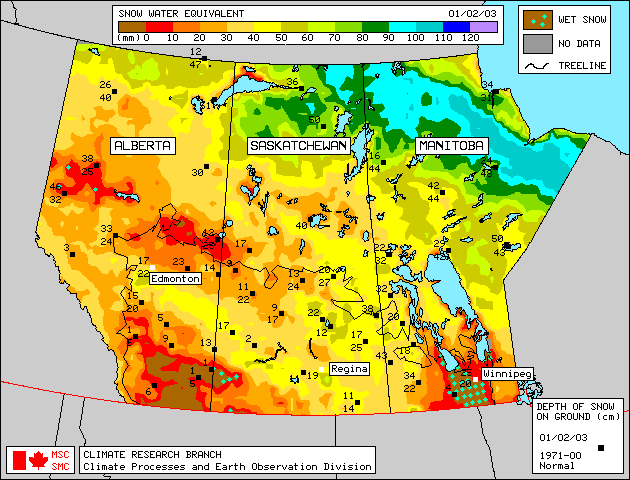
Plains SnowpackSatellite estimation of snow water equivalent and snow depth shows plains area snowpack is much-below-average as of February 1, 2003, except near-normal to above-normal in a band from the Peace River area through the Edmonton region and into Saskatchewan (Figure 1). South of Calgary, plains area snowpack is especially low, with little or no snow cover in these areas. Additional information on plains area snowpack will appear in the March Water Supply Outlook as snow course measurements will be conducted at the end of February. |
For technical enquires about this web page please contact Alberta Environment - Environmental Management Water Management Operations Branch at AENV-WebWS@gov.ab.ca