Water Supply Outlook for Alberta
February 2004
Mountain Snowpack |
|
Snow accumulations in the mountains as of February 1, 2004 are generally below-average to average in the Waterton/St.Mary, Bow, North Saskatchewan, and Athabasca River basins, average to above-average in the Oldman and Red Deer River basins, and below-average to much-below-average in the Smoky River headwaters for this time of the year (Table 1). The mountain snowpack is an important source of water supply to reservoirs in the province. On average, the accumulation of snow at this time of the year accounts for nearly two-thirds of the seasonal total. Eight snow courses were measured at the end of January in the Oldman River basin, with values ranging from 88 to 117% of average for this time of year (Table 2). Snow accumulations are average to above-average and are generally much better than those observed on February 1 of both 2003 and 2002, and noticeably improved from last month. Eighteen snow courses were taken at the end of January in the Bow River basin, with values ranging from 79 to 114% of average (Table 3). Snowpack measurements are generally below-average to average for this time of year in the upper Highwood, Elbow, and Kananaskis River basins, and near average in the upper Bow River basin. Snow accumulations are generally much higher than those observed last year at this time and lower than those recorded in January 2002, and slightly improved since last month. Two snow courses were measured in the Red Deer River basin on February 1, with snowpack at Limestone Ridge at 124% of average, which is above-average for this time of year. The snow pillow at Skoki Lodge indicates normal snowpack. Three snow course measurements were made in the upper North Saskatchewan and Athabasca River basins this month, with accumulations ranging from 78 to 91% of average, which is below-average to average for this time of year (Table 4). Snow accumulations are generally higher than those observed last year at this time. At twelve snow course sites, real-time snow accumulation can be monitored using snow pillows. Snow pillows can be viewed by choosing any mountainous southern basin, and snow data, in the two drop down menus at: Snow water equivalent values on the snow pillow may or may not match the snow course value at a particular location. While snow pillow data is very valuable information, the quantity of snow on the pillow is only representative of the accumulation at that specific spot. A snow course survey is measured at numerous spots and provides a more representative value of snow in the area. In some locations, there can be considerable difference between the snow pillow and snow course values. Factors such as wind and exposure of the site can cause the snow pillow values to be significantly different from the snow course survey. The snow pillow graphs on our website show the daily average snow water equivalent. The monthly snow survey is the average of all measurements conducted within five days of the end of the month. Also, where snow pillow and snow course measurements are available for the same site, snow pillow records tend to be much shorter (10-15 years) in length compared to the snow course sites. As a result, the difference in the average value between the snow pillow and the snow course can be attributed to snow water equivalent being derived two different ways (physically measured compared to an instrument reading), site location and length of data record. In some cases, the values can deviate by 10-20%. Therefore, while snow pillows are excellent for analyzing trends and for monitoring accumulation between snow surveys, snow course values should always be used when considering the quantity of snow at a particular location as they best represent that area. Click here to see a map of snow course locations
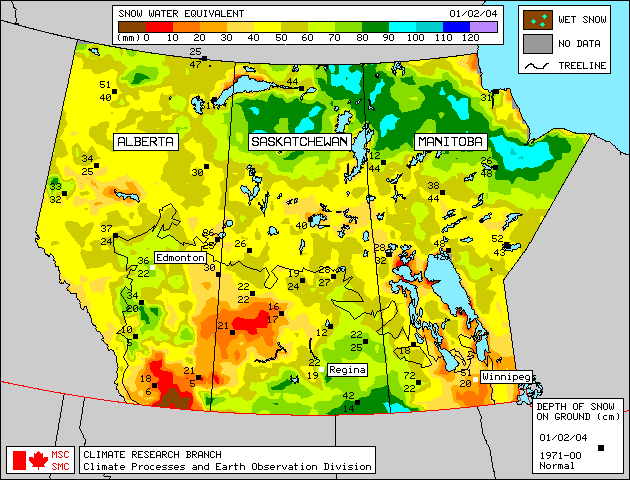
Plains SnowpackSatellite estimation of plains snowpack as of February 1, 2004 is available in Figure 1. Weekly updates to the satellite maps are available on the Meteorological Survey of Canada website . Despite generally much-below-normal precipitation this winter, above-normal to much-above-normal January snowfall has resulted in approximately average to above-average snowpack in most plains areas, with the exceptions of northeastern Alberta and the Milk River area which have approximately below-average snowpack. Snowpack in the Cypress Hills is estimated to be near record high levels. More detailed information on plains area snowpack will appear in the March Water Supply Outlook as plains snow course measurements will be conducted at the end of February. |
For technical enquires about this web page please contact Alberta Environment - Environmental Management Water Management Operations Branch at AENV-WebWS@gov.ab.ca