Water Supply Outlook for Alberta
February 2005
Mountain Snowpack |
|
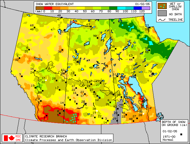
Snow accumulations in the mountains as of February 1, 2005 generally improve moving from south to north. Measured snowpacks are much below average in the Oldman River basin, below average to average in the Bow River basin, average in the Red Deer and North Saskatchewan River basins, and above average to much above average in the Athabasca River basin for this time of the year. Snowpack in the upper Peace River basin, in British Columbia, is generally average. The mountain snowpack is an important source of water supply to reservoirs in the spring. On average, the accumulation of snow at this time of the year accounts for nearly two-thirds of the seasonal total. Eight snow courses and two automated snow pillow readings were taken at the end of January in the Oldman River basin. Values range from 0 to 71% of average for this time of year, not including two locations which do not have a long enough period of record (Table 1). Record lows were measured at four locations, and the other locations ranked among the lowest five on record, in up to thirty years of data. Rainfall and very warm temperatures during mid-January melted much of the snowpack, especially at lower elevations. All four locations below 6000 feet of elevation had record low snowpack, and the three of these below 5000 feet had little to no snow left. Values above 6000 feet range from 65 to 71% of average, much below average for this time of year. Eleven snow courses and two automated snow pillow readings were measured at the end of January in the Bow River basin, with values ranging from 84 to 119% of average (Table 2). Snow accumulations are near average for this time of year upstream of Banff, with snowpack near the basin divide with the North Saskatchewan River basin being above average to much above average. The basin to the south of Banff has generally below average snow accumulations. One snow pillow and two snow course measurements in the Red Deer and North Saskatchewan River basins show accumulations ranging from 96 to 102% of average on February 1, 2005, which is average for this time of year. Two snow course measurements in the Athabasca River basin were 117 and 142% of average, which is above to much above average for this time of year (Table 3). The Marmot-Jasper snow course ranked a record high, however there are only eight years of record. Snowpack in the upper Peace River basin in British Columbia is generally average, as seen in the B.C. Snowpack and Water Supply Outlook (http://wlapwww.gov.bc.ca/rfc/river_forecast/bulletin.htm#Northeast). Snowfall accumulations on snow pillows during the first ten days of February have been generally above average in the upper Red Deer, Bow and Oldman River basins, which is an encouraging start to the month. Further snow course measurements will be taken at the end of February. At twelve snow course sites, real-time snow accumulation can be monitored using snow pillows. Snow pillows can be viewed by choosing any mountainous southern basin, and snow data, in the two drop down menus at: Snow water equivalent values on the snow pillow may or may not match the snow course value at a particular location. While snow pillow data is very valuable information, the quantity of snow on the pillow is only representative of the accumulation at that specific spot. A snow course survey is measured at numerous spots and provides a more representative value of snow in the area. In some locations, there can be considerable difference between the snow pillow and snow course values. Factors such as wind and exposure of the site can cause the snow pillow values to be significantly different from the snow course survey. The snow pillow graphs on our website show the daily average snow water equivalent. The monthly snow survey is the average of all measurements conducted within five days of the end of the month. Also, where snow pillow and snow course measurements are available for the same site, snow pillow records tend to be much shorter (10-15 years) in length compared to the snow course sites. As a result, the difference in the average value between the snow pillow and the snow course can be attributed to snow water equivalent being derived two different ways (physically measured compared to an instrument reading), site location and length of data record. In some cases, the values can deviate by 10-20%. Therefore, while snow pillows are excellent for analyzing trends and for monitoring accumulation between snow surveys, snow course values should always be used when considering the quantity of snow at a particular location as they best represent that area. Click here to see a map of snow course locations Plains SnowpackSatellite estimation of plains snowpack as of February 1, 2005 suggests below average to average snowpack in most areas of northern and central Alberta, and little snow left in southern Alberta (Figure 1). Snowfall the first week of February improved the snowpack somewhat, especially in central Alberta. Weekly updates to this satellite map are available on the Meteorological Survey of Canada website . More detailed information on plains area snowpack will appear in the next Water Supply Outlook, as snow course measurements will be conducted at the end of February. |
For technical enquires about this web page please contact Alberta Environment - Environmental Management Water Management Operations Branch at AENV-WebWS@gov.ab.ca