Water Supply Outlook for Alberta
February 2006
Mountain Snowpack |
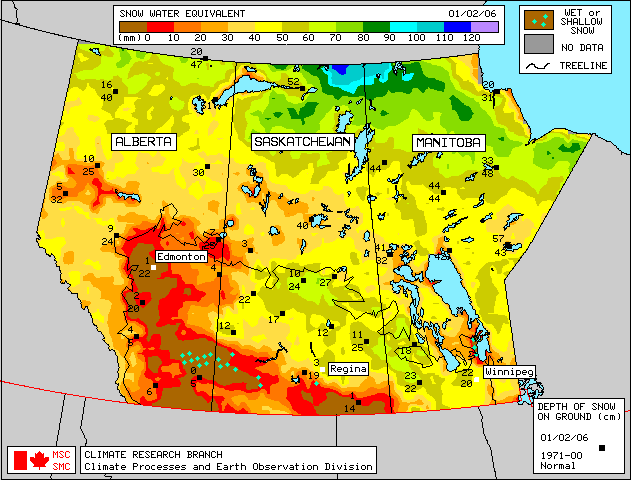
Snow accumulations in the mountains as of February 1, 2006 are above average in the higher elevations of the Oldman and Elbow River basins, average in the Kananaskis River Basin, below average in the remainder of the Bow River basin and below average to much below average in the Red Deer, North Saskatchewan and Athabasca River basins (Table 1). Three measurements at sites below 5000 feet of elevation in the Oldman River Basin showed below to much below average snowpack. Generally, snowpack accumulations are lower as you move northward. The mountain snowpack is an important source of water supply to reservoirs in the spring. On average, the accumulation of snow at this time of the year accounts for nearly two-thirds of the seasonal total. Seven snow courses and three automated snow pillow readings were taken at the end of January in the Oldman River Basin. Three locations at lower elevations (4000 to 5000ft) ranged from below average to much below average, while five locations at higher elevations were above average. Two locations only have four years of data, but appear to have below average snowpack (Table 2). Generally snow accumulations are higher than at this time last year, even at lower elevations. Eighteen snow courses were measured at the end of January in the Bow River Basin, with values ranging from 59 to 118% of average (Table 3). Snow accumulations are generally below average except in the mountains of the Elbow and Kananaskis basins where accumulations are above average and average, respectively. Snow courses are lower than 2005 in all but the Kananaskis area, but much higher than 2001 and 2003 for all areas. One snow course and one automated snow pillow reading in the Red Deer River basin show the snowpack at 65 and 85% of average as of February 1, 2006, which is below average to much below average for this time of year (Table 4). This data indicates snowpack is lower than at the start of February 2005, and ranks near 7th lowest out of 24 years on record. Two snow courses were measured in each of the upper North Saskatchewan River and Athabasca River basins at the end of January. The values were 71 and 79% in the Athabasca River Basin and 65 and 81% in the upper North Saskatchewan River Basin, which are below average to much below average for this time of year. Measured values are lower than those observed in 2005. Of the four snow courses, three had values higher than observed in 2001, with the exception being Limestone which is on the divide between the upper North Saskatchewan River and Red Deer River basins. Three snow courses measured in British Columbia in the upper Smoky River Basin indicate the snowpack is generally below average. Three snow pillows in the upper Peace River Basin in British Columbia show the snowpack is generally below average to much below average, as seen in the snow pillow plots available at: http://www.env.gov.bc.ca/rfc/river_forecast/asp_com.htm. At twelve snow course sites, real-time snow accumulation can be monitored using snow pillows. Snow pillows can be viewed by choosing any mountainous southern basin, and snow data, in the two drop down menus at: Snow water equivalent values on the snow pillow may or may not match the snow course value at a particular location. While snow pillow data is very valuable information, the quantity of snow on the pillow is only representative of the accumulation at that specific spot. A snow course survey is measured at numerous spots and provides a more representative value of snow in the area. In some locations, there can be considerable difference between the snow pillow and snow course values. Factors such as wind and exposure of the site can cause the snow pillow values to be significantly different from the snow course survey. The snow pillow graphs on our website show the daily average snow water equivalent. The monthly snow survey is the average of all measurements conducted within five days of the end of the month. Also, where snow pillow and snow course measurements are available for the same site, snow pillow records tend to be much shorter (10-15 years) in length compared to the snow course sites. As a result, the difference in the average value between the snow pillow and the snow course can be attributed to snow water equivalent being derived two different ways (physically measured compared to an instrument reading), site location and length of data record. In some cases, the values can deviate by 10-20%. Therefore, while snow pillows are excellent for analyzing trends and for monitoring accumulation between snow surveys, snow course values should always be used when considering the quantity of snow at a particular location as they best represent that area. Click here to see a map of snow course locations Plains SnowpackSatellite estimation of plains snowpack as of February 1, 2006 shows little to no snowpack in most of the Alberta plains (Figure 1). Point measurements of snow depth on this map indicate snowpack is well below normal in all plains areas of Alberta. More detailed information on plains area snowpack will appear in the March Water Supply Outlook as snow course measurements will be conducted at the end of February. |
For technical enquires about this web page please contact Alberta Environment - Environmental Management Water Management Operations Branch at AENV-WebWS@gov.ab.ca