Water Supply Outlook for Alberta
May 2006
Mountain Snowpack |
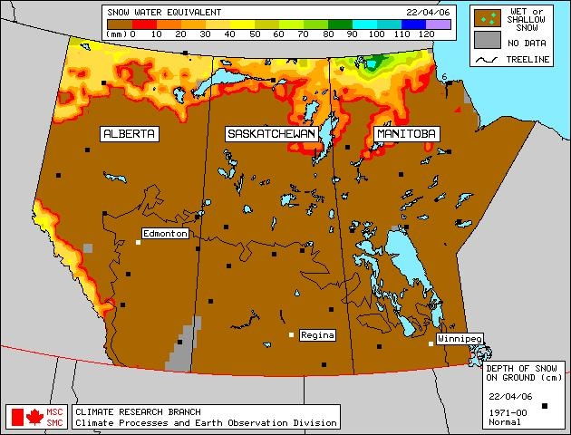
Snow accumulations in the mountains as of May 1, 2006 are generally better in the south than in the north (Table 1). Measured snowpacks are much below average in the northern basins (Athabasca, North Saskatchewan and Red Deer River basins), below to much below average in the Highwood River basin, below average to average in the Oldman River basin, and near average in the remainder of the Bow River basin. Snowpack in the upper Peace River basin, in British Columbia, is generally below average to average. An early May snowfall in the upper Bow and Oldman River basins provided 20 to 30 cm of new snow after some of the snow courses were completed, however this will not significantly change the overall condition of the snowpack. The mountain snowpack is an important source of water supply to reservoirs in the spring. Snow accumulation for the year is essentially complete. Twelve snow courses and two automated snow pillow readings were taken at the end of April in the Oldman River basin. Values range from 46 to 122% of average for this time of year, although snow at the Many Glacier pillow has all melted which happens often (Table 2). In the St. Mary's, Waterton and Belly River basins, most measurements ranged from below average to average, however snow at Akamina is above to much above average. Snowpack in the Oldman River basin varies from below average in the north to above average in the south (Castle/Crowsnest River basins). Fourteen snow courses were measured at the end of April in the Bow River basin, with values ranging from 75 to 103% of average, except for the one station at an elevation below 6000 ft which had a value of 19% of average (Table 3). Snow accumulations are generally average in upper Bow River and Elbow River basins, with only one of ten stations in these areas recording below average snowpack. This is an improvement from last month when conditions were generally below average. Four stations in the Highwood River basin show below to much below average snowpack in the basin. Three snow course measurements were taken at the end of April in the Red Deer River Basin, with values ranging from 60 to 88% of average, which is below to much below average. Snowpack in the basin ranges from fourth to tenth lowest in about 25 years of record (Table 4). Seven snow courses were measured in the North Saskatchewan River basin at the end of April, with values ranging from 14 to 81 % of average. The snowpack is much below average for this time of year, ranking from second to seventh lowest in approximately 25 years of record (Table 4). Snowpack in the basin is similar to 1998 & 2004. Two snow courses were measured in the Athabasca River basin at the end of April, with values of 19 and 56 % of average, which are much below average, each ranking third lowest in 37 years of record (Table 4). Snowpack in the upper Peace River basin in British Columbia is generally below average to average, as seen in the B.C. Snowpack and Water Supply Outlook (http://www.env.gov.bc.ca/rfc/river_forecast/bulletin.htm). At twelve snow course sites, real-time snow accumulation can be monitored using snow pillows. Snow pillows can be viewed by choosing any mountainous southern basin, and snow data, in the two drop down menus at: Snow water equivalent values on the snow pillow may or may not match the snow course value at a particular location. While snow pillow data is very valuable information, the quantity of snow on the pillow is only representative of the accumulation at that specific spot. A snow course survey is measured at numerous spots and provides a more representative value of snow in the area. In some locations, there can be considerable difference between the snow pillow and snow course values. Factors such as wind and exposure of the site can cause the snow pillow values to be significantly different from the snow course survey. The snow pillow graphs on our website show the daily average snow water equivalent. The monthly snow survey is the average of all measurements conducted within five days of the end of the month. Also, where snow pillow and snow course measurements are available for the same site, snow pillow records tend to be much shorter (10-15 years) in length compared to the snow course sites. As a result, the difference in the average value between the snow pillow and the snow course can be attributed to snow water equivalent being derived two different ways (physically measured compared to an instrument reading), site location and length of data record. In some cases, the values can deviate by 10-20%. Therefore, while snow pillows are excellent for analyzing trends and for monitoring accumulation between snow surveys, snow course values should always be used when considering the quantity of snow at a particular location as they best represent that area. Click here to see a map of snow course locations Plains SnowpackSatellite estimation of plains snowpack as of April 22, 2006 shows most areas of Alberta were bare of any snow, and with the warm temperatures in the last week of April it is likely all the plains snow has since melted (Figure 1). |
For technical enquires about this web page please contact Alberta Environment - Environmental Management Water Management Operations Branch at AENV-WebWS@gov.ab.ca