Water Supply Outlook for Alberta
April 2007
Plains Snowpack |
|
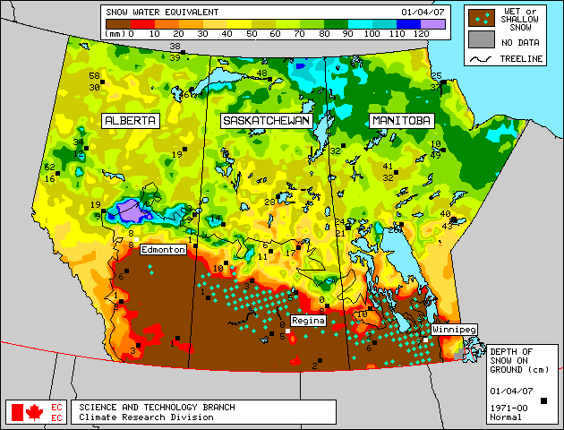
Of 12 snow courses in the Grande Prairie-High Prairie-Peace River region, five broke snowpack records by a significant margin (20 to 70mm higher) and six others are second highest in generally 35 years of record (Figure 1). Snow water equivalents in this region as of April 1 generally increased from between 10 to 75mm from the record and near record high March 1 values, due to much above average precipitation during the month. Across North Central Alberta (Edson-Slave Lake-Cold Lake-Lloydminister area) two-thirds of all snow course locations had snowpack among the five highest on record, and all but one were among the top ten. Above average snowpacks were measured in the Fort Chipewyan and High Level regions at the end of March, with most locations having snowpacks ranking among the ten highest in up to 35 years of record. Generally 15 mm of snow water equivalent fell in the High Level area since measurements were taken, increasing the snowpack somewhat. Warm March temperatures south of Edmonton have depleted most snowpacks in the Red Deer-Coronation area, with 8 of 14 snow course locations recording no snow water equivalent and the remaining locations measuring below to much below average. Satellite estimation of plains snowpack as of April 1, 2007 is available in Figure 2. The April 1 satellite map shows that most of the plains snowpack south of Edmonton has melted. Weekly updates to this satellite map are available on the Meteorological Survey of Canada website .
|
For technical enquires about this web page please contact Alberta Environment - Environmental Management Water Management Operations Branch at AENV-WebWS@gov.ab.ca