Water Supply Outlook for Alberta
February 2008
Mountain Snowpack |
Snow accumulations in the mountains as of February 1, 2008 generally range from average to above average in the Oldman River basin, below average to average in the Bow River basin and are below average in the Red Deer and North Saskatchewan River basins and above average in the Athabasca River basin (Table 1). The mountain snowpack is an important source of water supply to reservoirs in the spring. On average, the accumulation of snow at this time of the year accounts for nearly two-thirds of the seasonal total. Eight snow courses and two automated snow pillow readings were taken at the end of January in the Oldman River Basin, with values ranging from 87 to 145% of average. Generally the snowpack is average in the St. Mary and Oldman River basins and above average in the Waterton and Belly River basins. Snow accumulations at 6 stations in the Oldman River basin range from below average to above average. At two stations in the Waterton River Basin it is above average and at two locations in the St. Mary River basin one is below average and one is above average (Table 2). Fifteen snow courses were measured at the end of January in the Bow River basin, with values ranging from 83 to 123% of average (Table 3). Snow accumulations are generally average to below average in the Upper Bow River basin, as well as the Cascade, Elbow and Highwood River basins, and average in the Kananaskis and Spray River basins. Most basin snow course measurements were much lower than at this time last year, except for one in the Upper Bow River basin and one in the Highwood River basin. One snow course was measured in the Red Deer River basin indicating the snowpack is 89% of average as of February 1, 2008, which is below average for this time of year (Table 4). A snow course at Limestone, which is on the watershed divide of the Red Deer and North Saskatchewan River basins, is 84% of average which is also below average. Another location in the North Saskatchewan River basin has a slightly below average snowpack. Measured values are much lower than those observed in 2007. Two snow courses were measured in the upper Athabasca River basin at the end of January. The values were 107 and 109% of average which is slightly above average for this time of year. Measured values are much lower than those observed in 2007. Snow course measurements in the upper Peace River basin in British Columbia indicate snowpacks are above normal for this time of year, as seen in British Columbia's Snowpack and Water Supply Outlook: http://www.env.gov.bc.ca/rfc/river_forecast/bulletin.htm.
At twelve snow course sites, real-time snow
accumulation can be monitored using snow pillows. Snow pillows can be viewed by choosing any mountainous southern basin,
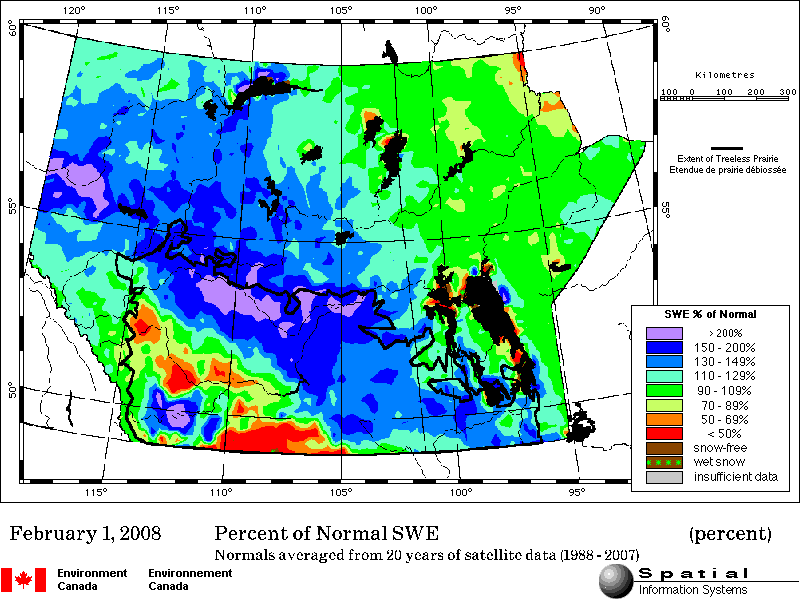
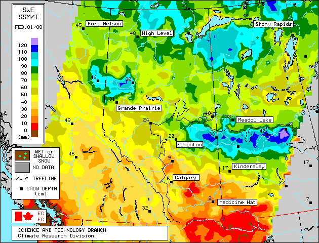
and snow data, in the two drop down menus at: Snow water equivalent values on the snow pillow may or may not match the snow course value at a particular location. While snow pillow data is very valuable information, the quantity of snow on the pillow is only representative of the accumulation at that specific spot. A snow course survey is measured at numerous spots and provides a more representative value of snow in the area. In some locations, there can be considerable difference between the snow pillow and snow course values. Factors such as wind and exposure of the site can cause the snow pillow values to be significantly different from the snow course survey. The snow pillow graphs on our website show the daily average snow water equivalent. The monthly snow survey is the average of all measurements conducted within five days of the end of the month. Also, where snow pillow and snow course measurements are available for the same site, snow pillow records tend to be much shorter (10-15 years) in length compared to the snow course sites. As a result, the difference in the average value between the snow pillow and the snow course can be attributed to snow water equivalent being derived two different ways (physically measured compared to an instrument reading), site location and length of data record. In some cases, the values can deviate by 10-20%. Therefore, while snow pillows are excellent for analyzing trends and for monitoring accumulation between snow surveys, snow course values should always be used when considering the quantity of snow at a particular location as they best represent that area. Click here to see a map of snow course locations Plains SnowpackSatellite estimation of plains snowpack as of February 1, 2008 shows the snowpack in Southern Alberta varies from below normal to above normal. There is an area of above normal snowpack which is bounded approximately by the High River-Pincher Creek-Foremost-Brooks area, and Cypress Hills. The remaining southern plains have normal to below normal snowpack. The central and northern plains have mostly above normal snowpack (Figure 1). Detailed information on plains area snowpack will appear in the March Water Supply Outlook as snow course measurements will be conducted at the end of February. Satellite estimation of plains SWE totals as of February 1, 2008 is shown in (Figure 2). |
For technical enquires about this web page please contact Alberta Environment - Environmental Management Water Management Operations Branch at AENV-WebWS@gov.ab.ca