Water Supply Outlook for Alberta
May 2005
Mountain Snowpack |
Snow accumulations in the mountains as of May 1, 2005 generally improve moving from south to north (Table 1). Measured snowpacks are much below average in the Oldman River basin and southern half of the Bow River basin, below to much below average in the northern half of the the Bow River basin and in the Red Deer River basin, and below average in the Athabasca and North Saskatchewan River basins for this time of the year. Snowpack in the upper Peace River basin, in British Columbia, is generally average. Snowpacks in all basins except the Oldman have decreased significantly since last month, due to mountain snowmelt starting a couple weeks earlier than usual, and very little April precipitation. Snowpack in the Oldman River basin remains near record lows. The mountain snowpack is an important source of water supply to reservoirs in the spring. Twelve snow courses and two automated snow pillow readings were taken at the end of April in the Oldman River basin. Values range from 0 to 69% of average for this time of year (Table 2). Snowpacks at all elevations showed little improvement during the past month and remain much below average. Record lows were set at five of the fourteen locations, and the rest had snowpack ranking among the lowest four on record in up to fifty-five years of data. Near record low snowpacks have been measured in the basin every month since January, when heavy rainfall and warm tempertures melted a significant amount of the snow. Fourteen snow courses were measured at the end of April in the Bow River basin, with values ranging from 14 to 88% of average (Table 3). Snow accumulations are below to much below average for this time of year upstream of Banff, which is a significant change from last month when the snowpack was below average to average. The snowpack in the Elbow, Highwood, Kananaskis, Cascade and Spray River basins is generally much below average, after being slightly better last month at below to much below average. Ten snow course measurements in the Red Deer and North Saskatchewan River basins show accumulations ranging from 32 to 91% of average on May 1, 2005, and two snow course measurements in the Athabasca River basin range from 73 to 79% of average (Table 4). Snowpack is below to much below average for this time of year in the Red Deer River basin, and below average in the North Saskatchewan and Athabasca River basins. Last month, the snowpack was above average in the Red Deer and Athabasca River basins, and average in the North Saskatchewan River basin. Snowpack in the upper Peace River basin in British Columbia is generally average, as seen in the B.C. Snow Pillow Commentary (http://http://wlapwww.gov.bc.ca/rfc/river_forecast/asp_com.htm). At twelve snow course sites, real-time snow accumulation can be monitored using snow pillows. Snow pillows can be viewed by choosing any mountainous southern basin, and snow data, in the two drop down menus at: As of April 11, it is evident from the pillow data that melting of the mountain snowpack has started again in the upper Oldman River basin, which is normal for this time of year. Further snow course measurements will be conducted at the end of April. Snow water equivalent values on the snow pillow may or may not match the snow course value at a particular location. While snow pillow data is very valuable information, the quantity of snow on the pillow is only representative of the accumulation at that specific spot. A snow course survey is measured at numerous spots and provides a more representative value of snow in the area. In some locations, there can be considerable difference between the snow pillow and snow course values. Factors such as wind and exposure of the site can cause the snow pillow values to be significantly different from the snow course survey. The snow pillow graphs on our website show the daily average snow water equivalent. The monthly snow survey is the average of all measurements conducted within five days of the end of the month. Also, where snow pillow and snow course measurements are available for the same site, snow pillow records tend to be much shorter (10-15 years) in length compared to the snow course sites. As a result, the difference in the average value between the snow pillow and the snow course can be attributed to snow water equivalent being derived two different ways (physically measured compared to an instrument reading), site location and length of data record. In some cases, the values can deviate by 10-20%. Therefore, while snow pillows are excellent for analyzing trends and for monitoring accumulation between snow surveys, snow course values should always be used when considering the quantity of snow at a particular location as they best represent that area. Click here to see a map of snow course locations
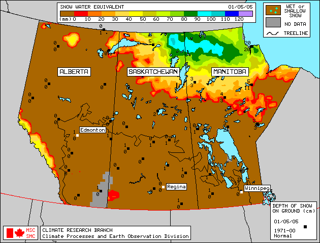
Plains SnowpackSatellite estimation of plains snowpack as of May 1, 2005 shows most areas of Alberta are bare of any snow, with a little left in the hills northeast of High Level and in the area northeast of Fort Chipewyan (Figure 1). |
For technical enquires about this web page please contact Alberta Environment - Environmental Management Water Management Operations Branch at AENV-WebWS@gov.ab.ca